US Topo Maps

US Topo Maps

Android Maps And Navigation ATLOGIS Geoinformatics GmbH & Co. KG
4.6 Popularity

Free offline topo maps app for outdoor adventures

System Requirements

Updated
September 16, 2025
Age Rating
Everyone
Android
Android 7.0++
Package Name
com.atlogis.northamerica.free

I've tested a bunch of different navigation and map apps, and US Topo Maps is one of the better ones I've come across. The sheer number of map layers and data sources they have access to is really impressive, and the offline capabilities are super useful. And in my experience, the app is generally pretty easy to use, though the UI can feel a bit cluttered at times. But the tradeoff is that you get a ton of functionality packed in. If you're an avid hiker, camper, or just love exploring the outdoors, this is definitely an app worth having in your toolkit.

Manya Lyalya
AUTHOR: Manya Lyalya Editor, Grand Screen

Pros

  • Tons of different map layers and data sources to choose from
  • Maps can be downloaded for offline use, so you don't need cell service
  • Solid GPS functionality to track your location and plot routes
  • Great for planning outdoor adventures and exploring new areas
  • It's completely free to download and use

Cons

  • The user interface can feel a bit cluttered and overwhelming at first
  • Some of the advanced features take a while to figure out
  • Occasional bugs or crashes, though the developers seem to update it regularly
  • Might be overkill if you just need basic navigation for casual hiking
GOOGLE PLAY SCORE
4.6 /5
based on 10,755 reviews
Generally Favorable
91
MY SCORE
Hover and click to give a rating
?
Rate this app

Description

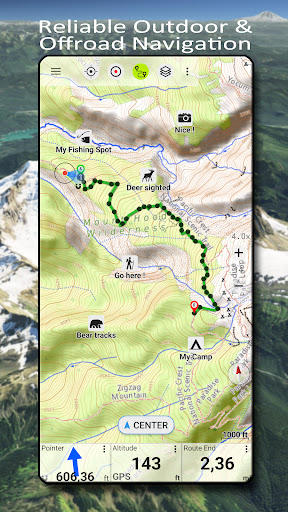
I’ve been using US Topo Maps for a couple months now. It’s basically an app that gives you free access to all kinds of detailed maps and imagery for the whole US. So whether you’re planning a hike, a camping trip, or just want to explore some new areas, this app’s got you covered.

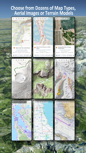
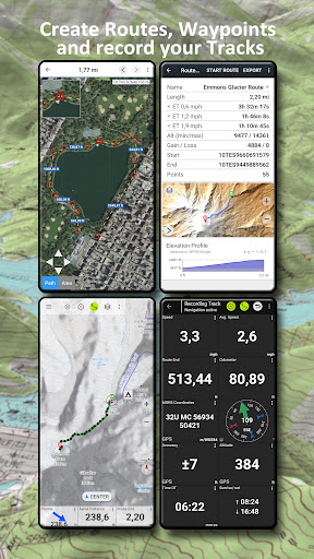
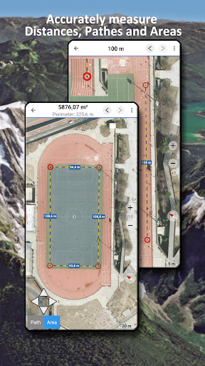
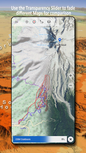
There’s over 30 different map layers you can choose from – things like topographic maps, aerial photos, nautical charts, and elevation data. It’s super handy for things like plotting your route, finding good campsites, or checking trail conditions before you head out. The maps download for offline use too, so you don’t need cell service when you’re out in the boonies.

Look, if you’re an outdoorsy person who likes to explore new places, you’ll probably really dig this app. It’s not perfect – the interface can be a little clunky at times – but overall it does a great job of giving you all the mapping tools you need for your adventures. Definitely worth checking out.

User Reviews

Perfect Pickles October 23, 2025

I use this more than OpenCPN for navigation as it allows me to save and use offline charts more intuitively (late 2025). Once Dave gets OpenCPN to function better maybe...

Kyle G October 23, 2025

Perfect, manual style map! Does everything you need without taking over your route for you.

SomeWiktAdmin October 23, 2025

This app represents the pinnacle of bureaucratic catch-22 nightmares. I am trying to determine the height of the crater walls of Kilauea summit caldera, at top and bottom of each...

Rate this app

Help others by rating key aspects of this app

Usability

50%

Features

50%

Design

50%

App Permissions

This app requires 5 permissions to function properly:

Device or other IDs

Data that may be shared with other companies or organizations

Crash logs

Data that may be shared with other companies or organizations

Diagnostics

Data that may be shared with other companies or organizations

User IDs

Data that may be shared with other companies or organizations

App interactions

Data that may be shared with other companies or organizations

Frequently Asked Questions